
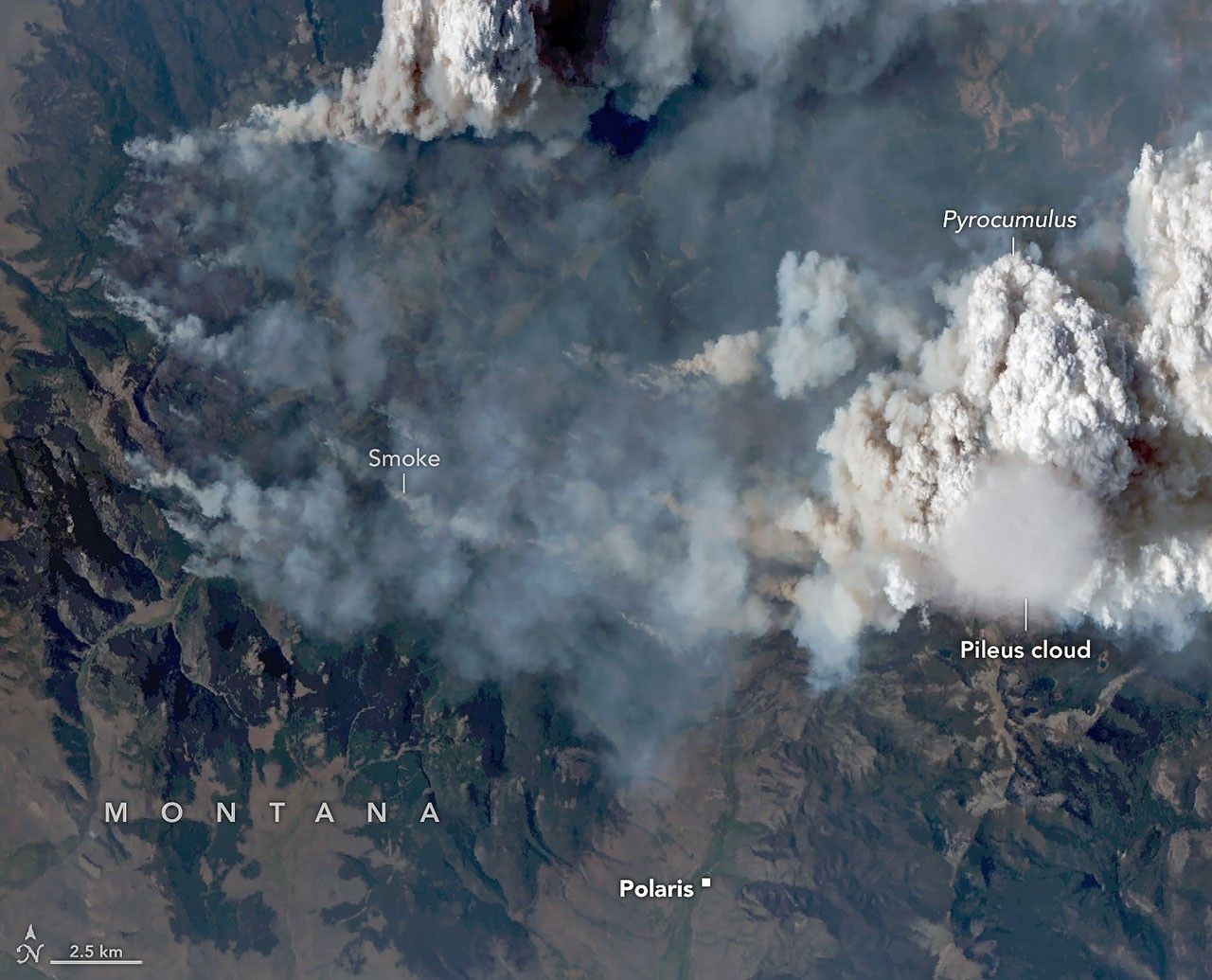
Fire Cloud with a Pileus on Top
In summer 2026, scientists took to the air to intercept and study the towering, smoke-infused clouds that wildland fires sometimes create. But during an August 11 flight over the Sand Creek fire in Montana, they came back with a bonus—observations of an ephemeral pileus cloud hovering atop one of the towering fire clouds.
Smooth, veil-like pileus clouds are well-known to atmospheric scientists and cloud lovers and regarded as signs of especially vigorous convection. But researchers rarely observe a pileus cloud interacting with a fire cloud—known as a pyrocumulus (pyroCu)—in as much detail as they did on this flight, part of NASA’s INSPYRE (Injected Smoke and Pyrocumulonimbus Experiment) campaign.
Named after the Latin for “cap,” pileus clouds typically form when rising columns of air collide with a sufficiently moist layer of air aloft. Over the Sand Creek fire, a fast-rising updraft heated by the fire displaced air vertically and forced a horizontal layer of moister air sitting above it upward. The process is similar to how air forced over a mountain can produce clouds, explained Neil Lareau, INSPYRE's deputy project investigator. "But in this case, the pyrocumulus itself was the 'mountain,'" he said. As the displaced air was pushed upward, it cooled, and its water vapor condensed into a pileus cloud.
The pair of images above was captured at 5:40 p.m. local time (23:40 UTC) by the MASTER (MODIS/ASTER Airborne Simulator) on one of NASA's ER-2s, a type of high-flying research aircraft. The natural-color image on the left shows the thin, circular pileus atop the turret of smoke and water rising from the spreading wildfire. The image on the right shows the same moment but includes shortwave-infrared (SWIR) observations, which reveal the burned area and actively burning spots along the fire’s perimeter.
Pileus clouds are usually quite short-lived, often persisting for only a few minutes before being overtaken by the underlying convection. During this flight, the scientists collected MASTER imagery of the plume roughly every 30 minutes, and the pileus was clearly visible in just one scene. The presence of the cloud hints at what Lareau described as the "extreme updraft dynamics" within the fire plume and pyrocumulus. At the time of the image, he explained, the fire was making a rapid run up the western side of Mount Comet as winds aligned with the drainage channels leading up the mountain.
"The whole scene is amazing," he said, noting that the science team was fortunate that MASTER's visible channels captured the rapidly developing pyrocumulus and pileus cloud, its infrared channels captured the fire's extreme surface behavior, and downward-pointing radars on the airplane studied the cloud structure. "This scene is in many ways the core of what we're after with INSPYRE," he said. "We were able to connect and map the surface fire dynamics to the convective plume to the cloud processes." The image above shows the cloud in four of the 50 channels, or bands, measured by MASTER. The false-color panel on the far right of the image is a combination of shortwave-infrared and visible observations, similar to the right image at the top of the page.
Fires are just one driver of convection that can produce pileus clouds. Vigorous updrafts associated with severe thunderstorms can also produce these wispy clouds. Researchers who participated in NASA's CRYSTAL-FACE (Cirrus Regional Study of Tropical Anvils and Cirrus Layers-Florida Area Cirrus Experiment) in Honduras in 2002 reported the presence of thin cirrus clouds in the tropopause above thunderstorms that were likely the products of pileus clouds.
Volcanic eruptions can produce pileus clouds as well. One of the more stunning images captured by astronauts and published by NASA Earth Observatory is this photograph of a pileus cloud cloaking the top of a volcanic plume rising from the Sarychev volcano after an eruption in 2009.
MASTER images by RoseAnne Dominguez (Airborne Sensor Facility), annotated by Michala Garrison. Story by Adam Voiland.
JPEG (1.08 MB)
JPEG (2.18 MB)
JPEG (570.68 KB)
Full text from nasa.gov (public domain).